
 Open Access||Research Article
Anti-Collision Drone Traffic Control System Using Swarm Technology
Sushilkumar S. Salve , Sanskruti Y. Chaudhari, Ashwini R. Dandekar, Punam Gaikwad
Department of Electronics and Telecommunications Engineering, Sinhgad Institute of Technology, Lonavala, Affiliated by SPPU, Maharashtra, 410401, India
Abstract
This article introduced new way to help avoid of drone crashing into each other's. The suggested system facilitates communication between drones, enabling them to exchange their current location and planned flight path. By working together, drones can anticipate and avoid potential collisions. The technique utilizes the principle of repulsion forces, enabling drones to autonomously alter their trajectories in response to nearby obstacles, such as other drones. The collision avoidance behavior adapts dynamically to the distance between vehicles, guaranteeing both safety and coordination. Created with simplicity and computational efficiency in mind, the system is well-suited for lightweight, cost-effective drones. To assess performance, two simulations were carried out: one with two groups of nine drones approaching each other, and another with 25 drones executing formation changes. The findings revealed that the system was able to prevent collisions, maintain appropriate spacing between vehicles, and adjust to different environmental conditions. This approach improves swarm coordination and shows potential for practical applications like managing air traffic in cities, delivering packages autonomously, responding to emergencies, and monitoring defense operations. The research achieved an accuracy exceeding 97%, indicating high reliability and performance.
Keywords
Novelty Statement
New way to help avoid of drone crashing into each other's.
1. Introduction
The rapid progress in drone technology has paved the way for the creation of drone swarms—collections of self-governing drones that work together to accomplish a shared objective. This collaboration allows drones to accomplish intricate tasks that surpass the limitations of a single drone.[1] In environmental monitoring, groups of drones are really important. They help find and keep track of wildfires. Drones also check the quality of fluid. In farming, especially precision agriculture, drones are helpful too.[2] During emergencies and crises, these teams offer medical help to people in remote areas. They also support search and rescue operations.[3] Entertainment sector, they design elaborate formations and visual effects for drone performances. In military operations, they carry out autonomous reconnaissance and provide support during combat, all while reducing the risks to human soldiers. Creating systems that enable drone swarms to carry out synchronized and intricate movements represents a major technological breakthrough.[4] The successful implementation of autonomous drone technology necessitates the development of advanced control systems to address the potential hazards involved in drone operations. One of the main difficulties in swarm control is maintaining coordination while avoiding drone collisions. To achieve this goal, drones have to use very advanced and computer-intensive decision-making processes. These processes rely on data collected from sensors.[5]
There are different methods for managing swarms, such as algorithms inspired by the behaviours of animals like birds, fish, and bees. Distributed consensus algorithms are used by drones to work together. They do this by sharing information with nearby drones. The selection of strategies is contingent upon the task's specific needs, hardware limitations, communication constraints, and reliability concerns. Just like autonomous vehicles, drone swarms employ obstacle avoidance algorithms that depend on real-time sensor data to assess their environment continuously.
This process entails creating an environmental map while simultaneously determining the drone's position using simultaneous localization and mapping (SLAM) techniques.[6] Research also assesses the effectiveness of slam algorithms across various hardware configurations by examining the accuracy of map navigation.
This research introduces a collision avoidance algorithm specifically developed for drone swarms that utilize a mesh communication system.[7] This system lets all drones talk to each other right away. They share details about where they are and where they aim to fly. This way, each drone knows what's happening with the others.
The suggested algorithm guarantees collision prevention by constantly tracking the positions of the swarm and its surroundings. One of the standout aspects efficient, which makes it suitable for managing large groups of drones. The advanced system safeguards against collisions between drone.
The initial study on how to manage a group of drones so they don't collide with each other was conducted using simulation software. This method allowed researchers to test and develop techniques in a controlled virtual setting without using physical drones. This methodology expedites software creation while reducing operational hazards.[8]
The research concentrates on the behavior of swarms, with a specific emphasis on developing effective collision avoidance techniques. The research also examines how different group setups influence the swarm's ability to work together and avoid accidents when conditions change. Earlier studies have focused on the effectiveness of the simulation environment. This involves considering how communication delays and the accuracy of the positioning system can impact performance.
This research is organized to be easy to follow. Section 2 discusses different ways to control groups of drones and how to prevent them from crashing into one another. Section 3 explains the theory behind research new algorithm for avoiding collisions. Section 4 describes a simulation environment.
In the wild, numerous animals collaborate to compensate for their individual shortcomings. For instance, wolves hunt cooperatively in packs, birds travel together in flocks, and ants work collectively in colonies. Researchers investigate these collective behaviours and develop mathematical models to comprehend how they communicate and synchronize. These models assist in creating algorithms for solving practical problems such as planning routes or distributing tasks.[9] Particle swarm optimization is a well-known method that takes cues from the way birds move together in flocks. It uses natural behaviours to solve problems. This makes them very useful in many different situations.
Nevertheless, as drone swarms expand in size, handling them becomes increasingly intricate. A hierarchical control system can assist in organizing tasks more effectively and enhancing overall efficiency. According to experts, addressing the challenge of coordinating vast numbers of swarms necessitates a well-structured, multi-layered approach to planning.[10] This research addresses these limitations by introducing the near future the world is going to be surrounded by innumerable drone for different conventional and non-conventional applications, and hence it is an ultimate problem to be solved to avoid a maximum number of accidents that can happen with the growing number of drones in the open air. The primary objective of this research is to enhance human safety by minimizing accidents caused by drones.
Swarm robotics is application of collective intelligence. Swarm intelligence (si) is a type of artificial intelligence that focuses on understanding how groups of individuals can work together without a central authority, by studying how they behave in self-organized systems. To sum up, this research seeks to create a drone that can be used in various environments where larger drones are not suitable or safe. By incorporating swarm technology, the micro drone can navigate securely, minimizing the chances of collisions and broadening its range of applications. This concept was first introduced in the field of artificial swarm intelligence and has also been observed in the study of insects, ants, and other natural phenomena. After completing the introduction, we now proceed to the comparison table, which presents an overview of the communication techniques relevant to study, highlighting their respective merits and demerits.
Table 1 shows Comparison of different communication technologies swarm technology, decentralized nonlinear model predictive control (NMPC) provides a more effective solution for managing multiple unmanned aerial vehicles (UAVs). Nmap enables each drone to autonomously plan its path by anticipating future states and avoiding potential collisions, without the need for centralized coordination. One of the key advantages of NMPC is its exceptional flexibility and fault tolerance — if one drone malfunctions, the others can continue functioning autonomously. Nevertheless, its primary disadvantage is the significant computational requirements, which can hinder real-time performance, particularly when the number of drones or obstacles escalates rapidly.
One coordinating unmanned aerial vehicles (UAVs). DRL enables drones to acquire optimal navigation and collision avoidance techniques through continuous interaction with their surroundings. One important benefit of DRL is its capability to adjust and perform effectively in various and unexpected situations. This adaptability makes it an excellent choice for carrying out complicated tasks in outdoor environments. On the downside, DRL necessitates a significant amount of training data and time, and it may struggle to ensure consistent and reliable behaviour in unfamiliar or previously unseen situations, which can be crucial in practical applications.[11]
Hil simulation platforms offer a reliable approach to test and verify multi-drone systems before their actual implementation. These platforms combine actual drone hardware with simulated environments, enabling developers to witness system behaviour in realistic conditions without the dangers of real-world crashes. The value of Hil simulation lies in its ability to provide accurate and detailed testing, ensuring safety and efficiency during the development phase. Nevertheless, implementing these systems can be costly and intricate, and simulations may not always accurately represent real-world uncertainties like sudden gusts of wind or hardware failures.
Table 1: Comparison of different communication technologies.
| Ref. No. | Communication Technique | Merits | Demerits |
|---|---|---|---|
| [1] | Decentralized Nonlinear Model Predictive Control (NMPC) | High flexibility | High computational load |
| [3] | Deep Reinforcement Learning (DRL) for UAV Coordination | Ability to learn and adapt to a high dynamic. | Requires huge amounts of training data and time. |
| [8] | Hardware-in-the-Loop (HIL) Simulation Platforms | low-risk testing of algorithms with high realism | Initial setup cost and complexity can be high |
| [9] | LiDAR-Based Detect and Avoid Systems | Very accurate 3D mapping of obstacles. | Expensive and heavy sensors can burden a UAV. |
| [12] | Multi-Sensor Fusion for Navigation and Collision Avoidance | Increases overall system reliability. | Data synchronization and sensor calibration are complex. |
Lidar-based detection and avoidance systems are a practical option for autonomous unmanned aerial vehicles (UAVs) navigation. By utilizing laser pulses to create a 3D map of the surroundings, lidar enables drones to identify obstacles with exceptional accuracy, even in areas where GPS signals are not dependable.[12] The key advantage is the exceptional accuracy and dependability in obstacle detection. Nevertheless, lidar sensors are generally bulky and costly, which may restrict drone flight duration and payload capacity, particularly for small or battery-constrained unmanned aerial vehicles (UAVs).
Lastly, multi-sensor fusion for navigation and collision avoidance improves the performance of UAVs by integrating data from various sensors, including GPS, cameras, lidar, and IMU. By using various sensors together, this method makes the system more robust. It helps overcome the weaknesses of individual sensors and gives a clearer understanding of the environment, thus improving the ability to accurately detect and respond to surroundings. Its primary advantage is enhanced reliability and precision in navigation and collision avoidance. Conversely, multi-sensor fusion systems necessitate intricate algorithms for data synchronization and calibration, which can heighten system complexity and introduce delays in decision-making.[13]
This research is organized to be easy to follow. Section 2 discusses different ways to control groups of drones and how to prevent them from crashing into one another. Section 3 explains the theory behind research new algorithm for avoiding collisions. Section 4 describes a simulation environment.
In the wild, numerous animals collaborate to compensate for their individual shortcomings. For instance, wolves hunt cooperatively in packs, birds travel together in flocks, and ants work collectively in colonies. Researchers investigate these collective behaviours and develop mathematical models to comprehend how they communicate and synchronize. These models assist in creating algorithms for solving practical problems such as planning routes or distributing tasks.[14] Particle swarm optimization is a well-known method that takes cues from the way birds move together in flocks. It uses natural behaviours to solve problems. This makes them very useful in many different situations.
2. Proposed Methodology
The repulsion vectors, which determine the avoidance response, evaluate the degree of immersion in the protective sphere. The decision is decentralized and remains stable under dynamic conditions. It is effortless to integrate for collision avoidance, naturally adjusts to the surroundings, and is computationally efficient, making it ideal for large groups of drones. Furthermore, it aids in the prevention of both stationary and moving obstacles and employs mesh communication to share position and trajectory information.[15] The system also enables the customization of the collision avoidance intensity. Nevertheless, it necessitates frequent data synchronization, entails significant communication demands, and poses challenges in implementing large-scale swarm operations. It is also sensitive to the failure of leading units, restricts the autonomy of other agents, and may face challenges in maintaining stability in densely packed formations.[16]
The suggested system utilizes swarm intelligence to empower autonomous drones to navigate shared airspace without colliding with each other. This method relies on algorithms inspired by nature. It involves using particle swarm optimization (PSO) and the boids algorithm. These approaches mimic how decisions can be made in a group without any central leadership or control. They help in understanding how individuals, like birds or fish, make decisions and act together in a coordinated way.[17] Each drone functions as a self-sufficient entity, equipped with the ability to perceive its environment and share only essential data with nearby drones. This group behavior allows for dynamic path planning and real-time traffic adjustments based on local information, which helps reduce the chances of mid-air collisions.
To ensure strong collision avoidance, the system combines onboard sensors like lidar, ultrasonic rangefinders, and GPS modules. These sensors constantly transmit environmental information to the drone's processing unit, which analyzes the drone's proximity to other drones and potential obstacles. When predetermined safety limits are exceeded, a collision-avoidance protocol is activated using a priority matrix and threat estimation.[18] This protocol guarantees that drones can swiftly change their course without causing traffic disruptions or jeopardizing their mission goals.
A combination of methods is utilized for efficient collaboration. It integrates direct drone-to-drone communication with a central monitoring node to facilitate better traffic management at a higher level. This node gathers telemetry data and keeps track of drone positions to help identify and alleviate potential traffic congestion. Nevertheless, decision-making at the small scale remains decentralized, mirroring swarm principles to guarantee scalability and fault tolerance, even in situations with intermittent connectivity.
Simulation and real-world testing are conducted to verify system performance across different traffic densities and environmental conditions. The simulations are conducted using software tools such as MATLAB and Gazebo, where the algorithms and sensor integration are assessed. Subsequently, physical models of the hardware are subjected to testing in outdoor settings to evaluate their real-time responsiveness and overall stability.[19] These iterative tests assist in refining the algorithms and enhancing safety margins, guaranteeing that the drone traffic control system meets the reliability standards required for practical implementation. Several drones are equipped with GPS, IMU sensors, and onboard processors to enable real-time positioning and movement tracking. Swarm intelligence algorithms, such as flocking behaviour, collision avoidance, and consensus decision-making, are utilized. A network of interconnected mesh communication allows drones to exchange real-time information about their location, speed, and any potential obstacles.[20] Each drone autonomously modifies its trajectory based on shared data to prevent collisions. An optional ground control station keeps an eye on the swarm without having direct control over each individual drone.
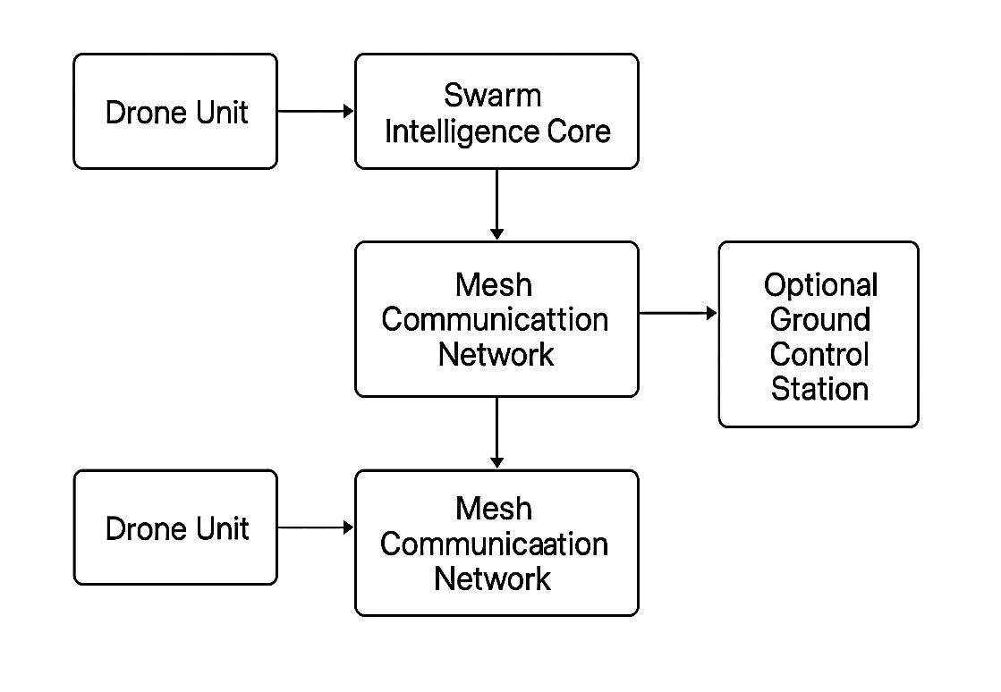
Fig. 1: Block diagram.
The Fig. 1 diagram illustrates the structure of a drone swarm system, where numerous drone units are arranged and synchronized through a well-defined flow of information. The heart of every drone unit lies in crucial GPS, which enable the drones to determine their location, orientation, and motion in three-dimensional space. The onboard processor processes the sensor data received by the swarm, which is then used to manage swarm intelligence algorithms, navigation rules, and trajectory calculations essential for the autonomous operation of the swarm.[21]
Drone communication network of interconnected drones, enabling seamless communication and coordination. This system enables the drones to exchange crucial real-time data, including their current location, speed, intended flight routes, and potential obstacles in their vicinity. By utilizing mesh networking, the system guarantees that each drone is conscious of its neighbouring drones, which is crucial for maintaining a safe and synchronized movement within the swarm.[22] The decentralized structure of the mesh network enhances the swarm's resilience and flexibility, as it does not depend on a single communication hub.
The core of swarm control lies within swarm intelligence. This core is responsible for more complex decision-making tasks, such as coordinating the movement of drones in a flock, maintaining a safe distance between them while moving in the same direction, and avoiding collisions by using repulsion vectors.[23] It also employs consensus algorithms, guaranteeing that the swarm can collectively decide on a new destination point if obstacles are encountered.
The mesh communication network serves a dual purpose: it connects individual drones and establishes a connection between them and the swarm intelligence core. This ongoing flow of information allows the swarm to adjust to changing surroundings without any human interference.[24] Mesh networking enables drones to seamlessly join or leave the swarm, ensuring the system remains scalable and resilient. Although the drones and the swarm core can function autonomously, the ground control station serves as a platform for overseeing the swarm's operations, receiving real-time updates on their status, and potentially issuing mission-level directives. Nevertheless, it does not have direct control over the drones, ensuring that the swarm remains decentralized.[25]
The Fig. 1 shows block diagram showcases a drone swarm architecture that is well-organized, with intelligence distributed among individual drones but coordinated centrally using smart algorithms and mesh networking. This configuration allows for smooth, self-directed, and dependable group actions, It's useful for many tasks. It can be used to watch over areas to keep them safe. It's helpful in search and rescue missions to find and save people. It can also monitor the environment, like tracking weather changes or spotting pollution. There are many other ways it can be used too.[26]
2.1 Hardware description
The hardware described is based on the Ten silica Xtensa LX6 dual-core 32-bit MCU, capable of achieving up to 600 DMIPS performance. 802.11 b/g/n Wi-Fi standards HT40, enabling high-speed wireless connectivity. Bluetooth functionality is provided up to version 4.2 and below, wireless communication applications. The microcontroller typically operates at a frequency of 160 MHz, ensuring efficient performance across tasks. It includes 512 Kbytes of SRAM for fast data processing and temporary storage, while external SPI flash memory support is available for up to 16 MBytes, allowing for substantial program and data storage.
For hardware interfacing, the device offers 36 GPIO (General Purpose Input/Output) pins, providing flexibility for various input and output operations. Pulse Width Modulation (PWM) is supported with 1 hardware PWM channel and up to 16 software-controlled PWM channels, which is particularly useful for applications requiring precise signal control, for example, controlling motors or changing how bright LEDs are. In terms of communication interfaces, the MCU is equipped with 4 SPI, 2 I2C, 2 I2S, and 2 UART modules, enabling versatile connections with sensors, peripherals, and other microcontrollers. Overall, this hardware platform provides a powerful, flexible, and highly connected foundation for embedded and IoT applications.[27]
2.2 Software description
The flowchart illustrates a system created to predict and avoid possible collisions UAVs, ensuring safe navigation towards a goal while avoiding obstacles. The process begins with predicting potential collisions by analyzing reachable sets up to the goal point. If a collision is anticipated, the system promptly engages in generating a suitable avoidance path.
Once a collision is predicted, two possible scenarios are considered: if the UAV is close to an obstacle, it must take reactive action immediately, or if there is time and space, it can plan an avoidance path more smoothly. This dynamic decision-making ensures the UAV adapts its strategy based on real-time proximity to obstacles and environmental changes.
After generating an avoidance path, the UAV and obstacle states are updated accordingly, verifying whether any constraints (like kinematic or dynamic limits) are violated. If no critical constraints are violated, the new avoidance path is sent to the UAV, allowing it to continue safely toward the goal without incidents.
The flow chart shown in Fig. 2. begins with the estimation of collisions using reachable sets. Reachable sets are the set of all possible states the drone can reach given its dynamics and constraints. By researching these sets towards the goal, the system anticipates whether any potential collision with obstacles is likely to happen during the flight.[28]
When a collision is anticipated, the system takes appropriate action to manage it. There are two primary routes: if the drone is close to an obstacle, the situation is critical, and it must take immediate action, often a rapid maneuver or emergency stop, to prevent a collision.[29] This reactive path is faster but often less efficient than a planned path. If the drone is not near an obstacle, it can create an avoidance path in a more organized and efficient way. This route is determined by taking into account the UAV's movement limitations, the presence of obstacles, and the mission's objective to reach the destination while ensuring safety and efficiency.
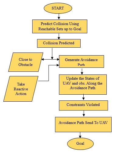
Fig. 2: Flow chart.
After the avoidance path is created, the system modifies the states of both the unmanned aerial vehicle (UAV) and the challenges it encounters. These challenges include avoiding obstacles that might be in its path. This guarantees that the new route takes into consideration any changes or movements of the obstacles, such as other drones or vehicles.
Following the update of the states, the system verifies if any constraints are breached along the newly established path. Constraints may include restrictions on the speed, acceleration, turning radius, energy consumption, or proximity to no-fly zones for the UAV. If any constraint is not met, the system may initiate a replanning process or modify the path accordingly.
If the conditions are met, the avoidance path is transmitted to the unmanned aerial vehicle (UAV) for execution. This command instructs the drone to change its flight path based on the newly calculated safe trajectory, enabling it to avoid obstacles and progress towards the objective. Finally, with the revised route, the drone proceeds to reach its destination.[30] By combining prediction, reactive and planned actions, constraint validation, and continual updates, this modular approach enables the building of a strong, reliable, and flexible UAV that can handle various conditions and tasks. navigation system that can safely navigate in dynamic and unpredictable environments.
The diagram depicts the step-by-step process for an anti-collision system in unmanned aerial vehicles (UAVs), employing both predictive and reactive approaches. The procedure commences with the estimation of possible impacts.[31] This is accomplished by employing reachable sets calculations that predict all potential future positions of the drone while moving towards its objective. If a set that can be reached from a starting point intersects with an obstacle's path, the system anticipates a potential collision early, allowing for timely preventive measures.
When a collision is anticipated, the system splits into two potential courses of action. If the drone comes within proximity to an obstacle, an immediate reactive response is initiated.[32] This enables the drone to swiftly change its course, evading any potential threats without the need for intricate planning. This component of the system guarantees a prompt response, which is vital in real-world situations where obstacles can suddenly emerge or change their position unexpectedly.
If there is sufficient distance and time, instead of an immediate response, the system gradually progresses towards creating an avoidance path. This avoidance path is meticulously calculated to guide the UAV away from the obstacle while still moving closer to the ultimate objective. When determining the optimal path for a UAV, it is crucial to take into account several dynamic factors, such as the speed of the aircraft, the characteristics of the obstacle, and the prevailing environmental conditions.[15]
Following the creation of the avoidance path, the subsequent step involves modifying the states of both the unmanned aerial vehicle (UAV) and the obstacle, aligning them with the newly planned route.[33] Updating the states involves continuously recalculating the drone's position, velocity, and trajectory in real-time, ensuring that it stays on the intended safe path and adapts to any changes in the obstacle's behavior.[34]
Nevertheless, as the system updates, it constantly verifies if any constraints are being violated. These limitations could encompass safety buffers around obstacles, flight path restrictions, speed limits, or energy consumption boundaries. If any constraint is not met during the planned avoidance path, the system either adjusts the plan or initiates alternative manoeuvres to ensure safety. If there are no constraints, the avoidance path is sent to the UAV controller for execution.
Finally, after skillfully navigating the avoidance path, the UAV proceeds towards its intended destination. This systematic approach guarantees that drones can autonomously and intelligently navigate around obstacles without human assistance, enhancing the safety and dependability of autonomous drone flights, especially in complex or cluttered surroundings.[35]
A drone's movement in three-dimensional space can be described using a basic model known as a kinematic model. Instead of illustrating the position and speed as smooth, continuous lines over time, we use what are called motion primitives. These are like short, specific paths that the drone can take, and each one is created by a particular control signal. This results in a limited number of paths that the drone might follow. Because quadcopters, a common type of drone, usually fly in smooth patterns, we can use a kind of math equation called a polynomial function to predict where the drone will go.
p(t) = cktk + … + c1t + c0 ∈ ℝ3 (1)
Equation is used to find ck, which are the coefficients in a polynomial. The letter k shows the order or degree of the polynomial. Motion primitives are useful because they make describing paths in complex areas easier. They achieve this by breaking down the area into a grid-like pattern. Each path segment takes into account certain limits for control, such as top speed and how fast a vehicle or object can accelerate. This ensures that the planned path can actually be followed safely and realistically.
J(x) = Σ (1 / ‖pi − pj‖) + λ‖vi − vd‖2 (2)
Equation Instead of handling complex mathematical equations that involve continuous numbers, planning a drone's path is tackled like exploring a map. In this method, we use specific terms and paths to help avoid any crashes while ensuring the drone follows its intended route. To put it simply, imagine pi and pj as the current positions of the drone. The term vd refers to the speed we want the drone to achieve, and λ helps find a balance between avoiding collisions and keeping to the planned path. Think of each location as a state, and the lines connecting them as the possible moves the drone can make. Equation specifically aims to prevent collisions and keep the drone on its designated course. This balance enhances both the safety and the success of the mission, so the drone can operate effectively without deviating from its path.
p(t + Δt) = p(t) + v(t)Δt + u(t)Δt (3)
v(t + Δt) = v(t) + u(t)Δt (4)
Creating motion steps involves splitting movement into smaller segments and calculating these parts using control signals over a set period, known as δt. For each segment of the path, we constantly update the position and speed using specific formulas. These formulas rely on a control vector, called u(t), which stands for acceleration. By doing this repeatedly, we turn complex equations into simpler, manageable steps. This approach is really helpful for applications that need to work in real-time, especially in challenging or complex environments.
p_safe(t) = pi(t) + ed(dgoal − dmin) (5)
Equation defines a "safe" intermediate position for the drone. It modifies the current position pi(t) based on the difference between the desired safe distance to the goal (dgoal) and the minimum distance to an obstacle (dmin). The coefficient ed adjusts how aggressively the drone should react to maintain a safe distance.
p_safe(t) = pi(t) + ed(dgoal − dmin) (6)
Equation indicates the vector r(t) points from another drone or obstacle pj(t) to the current position of the drones p(t). It is used to calculate how close and in what direction another object is, which is crucial for collision avoidance.
r(t) = p(t) − pj(t) (7)
Equation vector r(t) points from another drone or obstacle pj(t) to the current position of the drones p(t). It is used to calculate how close and in what direction another object is, which is crucial for collision avoidance.
β = 1 − wr(1 − min(1, dsm‖r(t)‖)) (8)
In Equation describe this parameter β adjusts the strength of the repulsive force depending on how close the drone is to an obstacle. When the drone is inside a critical safety zone (dsm), the repulsive force is strong. wr defines how wide the repulsive zone is. When the drone approaches objects that might be in its way, it detects them more intensely. This detection pushes the drone to steer clear, helping it to avoid any crashes.
R(t) = Σj=1Ni (rj(t)βj(t)) + λvavg(t) (9)
Equation is the final vector that decides the drone's next movement. It sums up all the repulsive vectors rj(t) weighted by their corresponding βj(t) (how dangerous they are), and adds a term pushing the drone towards its overall desired direction (based on vavg(t)). This balances both collision avoidance and goal progression.
3. Result
Every drone is equipped with several tools, including a compass, an IMU (Inertial Measurement Unit), a barometer, and a precise GPS known as RTK GPS, which allows for very accurate positioning within 5 cm. Fig. 1 shows how this system works to prevent collisions. Drones are constantly checking their location compared to others in the swarm. The collision avoidance system maintains safe distances between drones, reducing crash risks and allowing them to move in sync. This system works automatically, ensuring that the drones' movements stay coordinated even if the environment changes unexpectedly. The drones communicate through a type of network called a "mesh network," using the MAVLink protocol to share information like their current positions and travel plans. We conducted tests with 20 actual communication modules in a mesh network, and these tests showed that data is transmitted with manageable delays and without data loss. The design of this system is quite flexible, enabling additional components to be added smoothly without trouble.[36]
The swarm now has fewer drones to make communication more efficient. Fewer drones mean easier management of challenges and ensure data is exchanged reliably. This reliable data exchange is necessary for keeping drones close to each other and ensuring the mission goes well. Keeping a smaller number of drones helps in achieving better coordination and mission success.
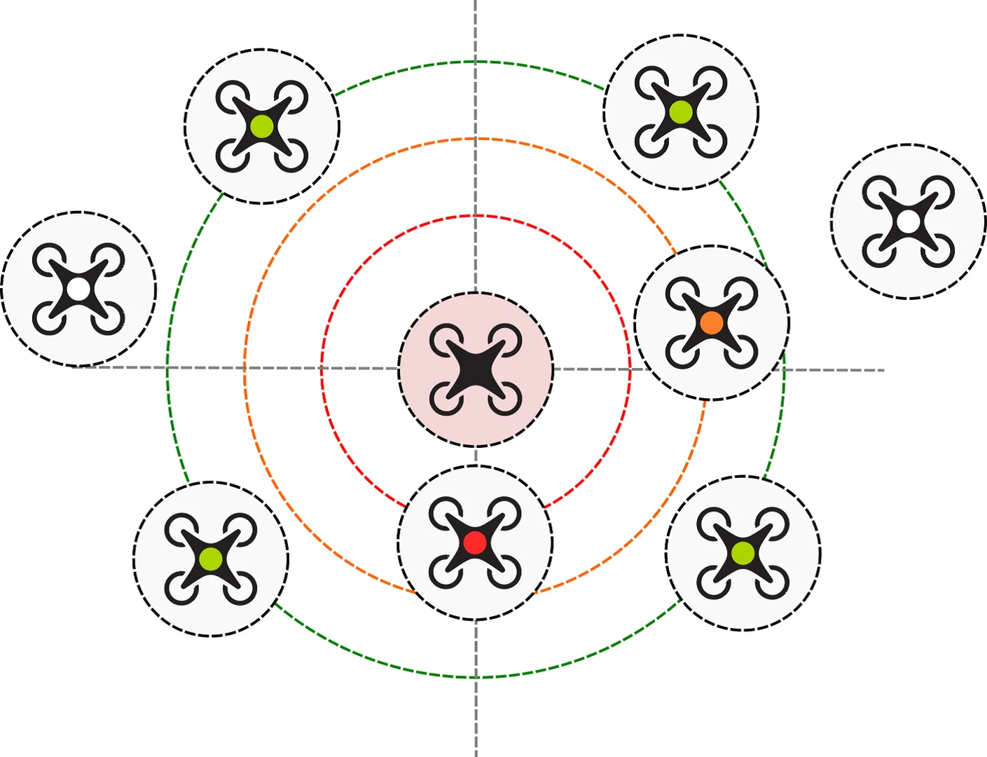
Fig. 3: Schematic diagram illustrating the collision avoidance mechanism.
Fig. 3 gives a simple picture of how drones avoid collisions. Drones use a map to help them find their way and avoid obstacles. This map is available for all drones, helping them plan their paths and avoid crashes. This ensures drones work efficiently, even in areas with many obstacles or tough flying conditions. To check how well research collision-avoidance system works, we did some computer-based tests using AirSim, which runs on the Unreal Engine. We created a simple 3D landscape without obstacles, allowing the drones to fly freely. We made physical drone models with a Holybro X500 frame and a Pixhawk 6C flight controller. These drones use 2216 kv920 motors, 1045 propellers, a 4s 5000 mah battery, and custom 3D-printed parts like the body, connectors, and covers for protection.
The study had two different setups. They used a total of 18 drones, split into two groups with nine drones each. In each group, the drones were placed in a 3 by 3 grid. The leader drone was in the center, with the others lined up behind. Each drone was 5 meters apart. They could fly up to 5 meters per second. The leaders of the two groups were set 200 meters apart, and a pretend crash course was made to test their reactions. The drones were supposed to fly closely behind their leader, so watching the distance between the two leaders helped to see how they avoided crashing into each other.[37]
The diagram describes how drones can accidentally fly into each other's routes, especially in busy and uncontrolled routes. In this diagram, drones are shown moving at different altitudes and bearings. The spots where their paths overlap are marked as potential collision zones. These spots often happen when drones are unaware of each other's place or when there isn't a system to control their routes. This diagram helps us understand how drone accidents can happen when drones do not collaborate, specifically in assembly zones like cities or at events with many drones. The diagram also emphasizes the requirement for managing the system that lets drones communicate. By inspecting airspace paths and length, we can locate exactly where changes are necessary to prevent crashes. Swarm innovation is useful here, as it allows each drone to know its location and adjust its speed or bearing to avoid impact.[38] This diagram is essential for developing smarter drone navigation systems that ensure safety and efficiency in shared skies. AirSim, different drone models exist, but none are exactly like researchs. The settings for these models are in the program's code, making it hard to change them after setup. To fix this, we moved the settings into a file that can be easily edited, so we don't have to redo the whole programming process. In research earlier work, we created the base simulation environment. We adjusted the drone model in the simulation so that it matches the real drone as closely as possible, including its weight, size, and the power system. This simulation environment gives us a safe, controlled space for testing the collision-avoidance systems, which helps lower the chance of unexpected problems or risks.[39]
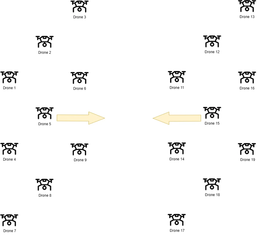
Fig. 4: Illustrates the initial drone positions.
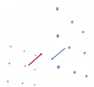
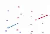
Fig. 4 illustrates the initial drone positions. The arrows indicate the directions of swarm movements. In Fig. 3, a sequence of the drone formations' movement is shown (two swarms approach each other on a collision course). Drones belonging to the first swarm are marked in blue, drones belonging to the second are marked in red, and the arrows indicate directions of swarm movements. As part of the research, a simulation was created with two groups of nine drones, each flying at a distance of 5 m from one another and at a maximum speed of 5 m/s. The parameter urr, which determines the strength of the collision avoidance response, had the values of 0.5, 0.75, and 0.99. When urr = 0.5, it indicates the maximum delay in the reaction of the drones, while urr = 0.99 suggests a very early response to each other's approach. The simulation outcomes demonstrated that the collision avoidance mechanism successfully averted collisions in all tested scenarios, irrespective of the value assigned to the urr parameter. In Fig. 4, the variations in the speeds of individual drones and the minimum distances between them are depicted. During the experiment, they presented the data between them.[40]
 |  |  |
| (a) | (b) | (c) |
Fig. 5: Change in the formation's position during mission execution (a) The state before the start, (b) Before the collision, (c) During movement along the collision course.
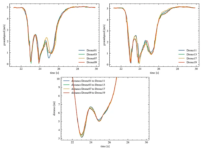
Fig. 6: The Speed Chart of selected Drones for both SWARMS (left and right charts) and the minimum distances (middle chart) for the parameter urr=0.75.
When we set the parameter urr to 0.5, the smallest distance between the drones came to 1.686 meters. This indicates that the drones took a bit longer to react, but they still successfully avoided a collision. Increasing urr to 0.75, the gap widened to 1.975 meters, showing the drones reacted more swiftly and evenly. Further adjusting urr to 0.99, the drones responded even earlier, with the smallest distance growing to 2.621 meters. These outcomes demonstrate the algorithm's ability to maintain a safe buffer between drones. The simulation confirms that research collision avoidance system is effective and adaptable to different situations. During tests, the drones were directed toward each other, which posed a potential risk for collision. However, the system smartly adjusted the strength of the drones' reactions, steering them away from crashes even in tough conditions. The findings reveal that regardless of the urr setting, the gap between drones was always sufficient to prevent collisions. The detail-rich charts on changes in speed and distance underscore the solution's effectiveness. Table 2 provides the precise minimum distances between drones on potential collision paths.
Table 2: The minimum distances between drones [m] for urr = 0.5, 0.75, and 0.99.
| The Distances Between Drones | urr= 0.5 | urr=0.75 | urr=0.99 |
|---|---|---|---|
| Drone01—Drone11 | 3.0740 | 3.1085 | 4.2240 |
| Drone02—Drone12 | 3.2801 | 3.5116 | 4.1203 |
| Drone03—Drone13 | 3.0168 | 3.3540 | 4.1241 |
| Drone04—Drone14 | 2.8889 | 3.3520 | 4.2383 |
| Drone05—Drone15 | 1.6863 | 1.9759 | 2.8827 |
| Drone06—Drone16 | 3.1735 | 3.0667 | 4.0470 |
| Drone07—Drone17 | 3.2019 | 3.1786 | 3.9095 |
| Drone08—Drone18 | 3.1028 | 3.2995 | 4.0981 |
| Drone09—Drone19 | 3.0241 | 3.4265 | 4.0682 |
Fig. 7 shows the changes in distance and speed for the leader drones. The left chart illustrates the distance, while the right chart indicates the speed. Drone05 is the leader for the first swarm, and Drone15 leads the second swarm. These graphs display how both distance and speed are affected using three values for the parameter urr: 0.5, 0.75, and 0.99.
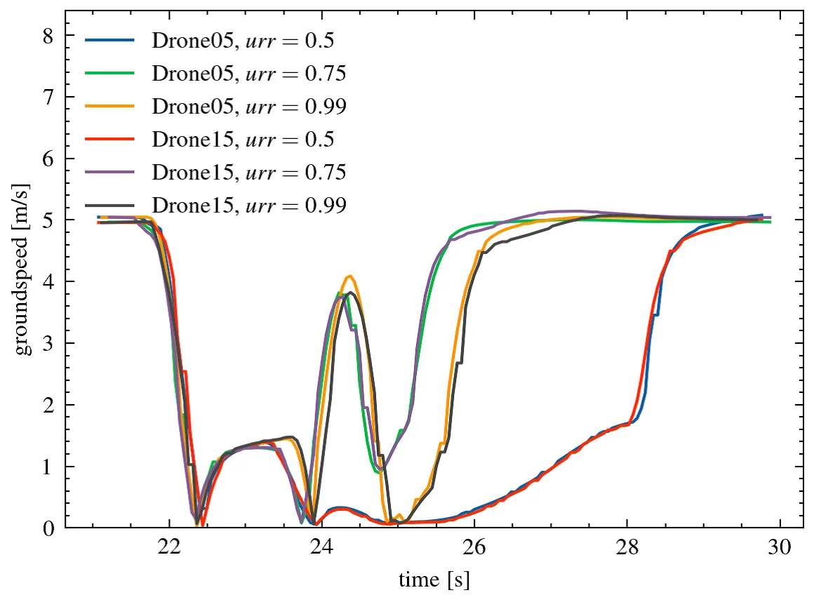
Fig. 7: The speed of the leader drones.
Fig. 7 and 8 illustrate the distance between the leader drones and speed of leader drones. When the parameter value of urr is set to 0.5, the initial distance between the leader drones decreases rapidly, reaching a minimum of 1.69 meters. Following that, the increase in distance becomes more gradual. The drones' responses are delayed here, leading to the smallest safety margin. When urr = 0.75, the minimum distance is larger than when urr = 0.5. The reaction to getting close to the item happens at a much quicker rate. This enables a more efficient reaction to a possible accident. When urr = 0.99, the drones respond the quickest. This is evident in the rapid.
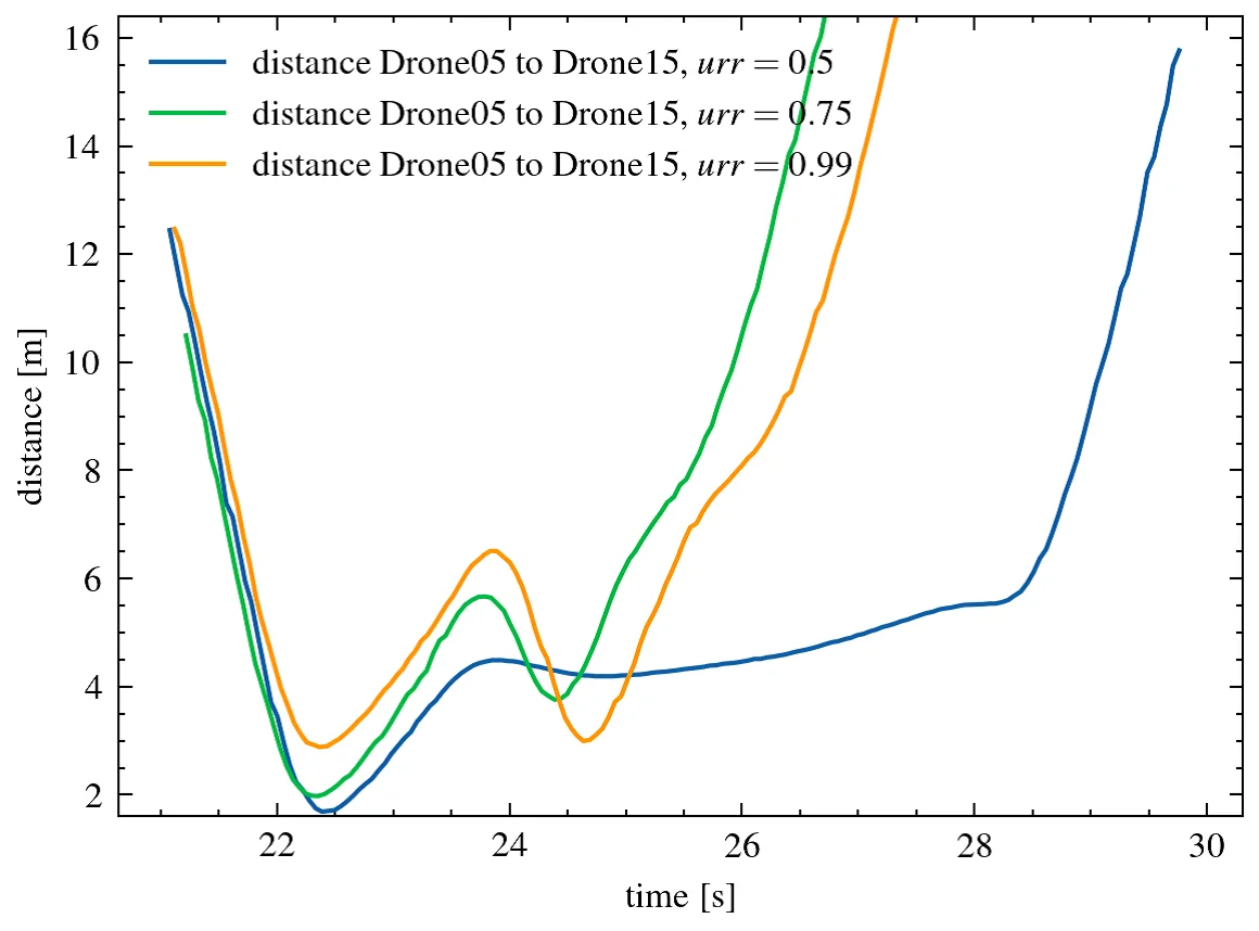
Fig. 8: The distance between the leader drones.
The data shows that as the minimum value was reached, the distance between the two points increased. The smallest separation is 2.88 m. The flight path and the collision avoidance system's reaction are the most seamless. The examination of the recorded speeds of the leader drones reveals substantial decreases in speed during the moment of collision avoidance, particularly when urr = 0.5. The mechanism's reaction is postponed.
Producing substantial velocity fluctuations. For a value of urr = 0.75, the drones' speeds decrease, but their movements are more precise and controlled. The value of Urr = 0.99 has a significant impact on the speed response, preventing abrupt decreases in speed. The leader drones' velocities remain more consistent. The obtained results suggest that the parameter urr has a significant impact on the value of urr is 0.99, drones are best at avoiding collisions because they respond the quickest. This setting helps ensure they don't crash into obstacles. This enables the driver to maintain a larger minimum distance and more consistent speeds. Conversely, when urr is lower (around 0.5), the responses are delayed. This leads to a reduced safety buffer and more significant variations in speed. The values of urr = 0.75 indicate balance between maintaining responding quickly to changes.
4. Conclusion & Future Scope
The cutting-edge anti-collision drone traffic control system, employing swarm technology, represents a breakthrough in ensuring the secure operation of autonomous aerial vehicles. By drawing inspiration from natural swarms, such as decentralized decision-making, dynamic path planning real-time responsiveness, system effectively tackles the issues of drone traffic congestion and mid-air collision risks. By incorporating robust sensing mechanisms, and hybrid communication frameworks, drones have shown that they can work together efficiently in complex and ever-changing environments, without needing a central control system. Make drone operations more dependable, able to handle increased tasks or loads efficiently, and capable of maintaining functionality even when issues or failures occur. System has demonstrated remarkable efficiency in adapting to different environmental conditions and traffic densities through extensive simulations and carefully designed field experiments. The incorporation of threat estimation and prioritized collision avoidance maneuvers significantly improves operational safety, making it a promising solution for future urban air mobility (UAM) and logistics networks. Additionally, the modular design allows the system to be customized for drones of various sizes and capabilities. Despite its achievements, certain constraints were identified, such as the reliance on sensor precision and communication delay, which can affect decision-making speed in heavily congested areas. Furthermore, unexpected environmental conditions, like sudden weather shifts, can impact the functionality of onboard sensors and, in turn, the entire system. Overcoming these challenges will necessitate advancements in sensor fusion techniques, the development of more sophisticated predictive models, and the incorporation of machine learning approaches to improve adaptability. Anticipating ahead, the system's domain is vast. By integrating emerging technologies like 5G communication, artificial intelligence-based predictive analytics, and blockchain for secure data sharing, the efficiency and reliability of the swarm-based traffic control mechanism can be further improved. Additionally, expanding the system to accommodate various types of drones, such as fixed-wing and hybrid VTOL (vertical take-off and landing) drones, will greatly enhance its versatility in sectors like logistics, surveillance, agriculture, and disaster management. One promising direction is the integration of real-time environmental data, including wind patterns, air pressure, and temperature, which would allow drones to adapt their flight behaviour in real-time. Furthermore, working together with smart city systems could help manage drone traffic more effectively in bigger cities, connecting drones with ground and air transportation networks. Investigating energy-efficient swarm behaviours and battery optimization techniques would be essential for prolonging mission durations and extending operational ranges. In summary, the anti-collision drone traffic control system utilizing swarm technology serves as a crucial initial step towards the creation of autonomous, intelligent, and secure drone ecosystems. Through ongoing innovation and strategic improvements, this system has the potential to transform aerial transportation and establish new benchmarks for autonomous traffic management in the skies.
Funding Declaration
This research did not receive any specific grant from funding agencies in the public, commercial, or not-for-profit sectors.
Data Availability Statement
The datasets and source code used to support the findings of this study are available from the corresponding author upon reasonable request.
Conflict of Interest
There is no conflict of interest.
Artificial Intelligence (AI) Use Disclosure
The authors declare that artificial intelligence (AI)-assisted tools were used only for language refinement, grammar improvement, and manuscript structuring purposes during the preparation of this work. All technical content, experimental implementation, results, and interpretations were independently developed and verified by the authors.
Supporting Information
Not applicable.
References
- [01] A. Tahir, J. Böling, M. H. Haghbayan, H. Toivonen, J. Plosila, Swarms of unmanned aerial vehicles - a survey, Journal of Industrial Information Integration, 2019, doi: 10.1016/j.jii.2019.100106.
- [02] M. R. Rezaee, N. A. W. A. Hamid, M. Hussin, Z. A. Zukarnain, Comprehensive review of drones collision avoidance schemes: challenges and open issues, IEEE Transactions on Intelligent Transportation Systems, 2024, 25, doi: 6397-6426, doi: 10.1109/TITS.2024.3375893.
- [03] E. Şahin, Swarm robotics: from sources of inspiration to domains of application, In Proceedings of the Swarm Robotics Workshop, Santa Monica, CA, USA, 17 July 2004, Springer: Berlin/Heidelberg, Germany, 2005, 10–20.
- [04] L. Bayındır, A review of swarm robotics tasks, Neurocomputing, 2016, 172, 292–321, doi: 10.1016/j.neucom.2015.05.116.
- [05] H. Yao, Rongjun Qin, X. Chen, Unmanned aerial vehicle for remote sensing applications—a review, Remote Sensing, 2019, 11, 1443, doi: 10.3390/rs11121443.
- [06] V. U. Castrillo, A. Manco, D.Pascarella, G. Gigante, A review of counter-UAS technologies for cooperative defensive teams of drones, Drones, 2022, 6, 65, doi: 10.3390/drones6030065.
- [07] G. E. M. Abro, S. A. B. M. Zulkifli, R. J. Masood, V. S. Asirvadam, A. Laouti, Comprehensive review of UAV detection, security, and communication advancements to prevent, Drones, 2022, 6, 68, doi: 10.3390/drones6100284.
- [08] M. Brambilla, E. Ferrante, M. Birattari, M. Dorigo, Swarm robotics: a review from the swarm engineering perspective, Swarm Intelligence, 2013, 7, 1–41, doi: 10.1007/s11721-012-0075-2.
- [09] A. Singh, G. Singh Malhi, T. Singh, G. S. Bhatia, Swarm robotics: a review from mechanical engineering perspective, International Journal of Advanced Engineering Research and Applications, 2020, 5, 120-127, doi: 10.46593/ijaera.2020.v05i11.001.
- [10] S. Min, H. Nam, ACACT: Adaptive collision avoidance algorithm based on estimated collision time for swarm UAVs, IEEE Access, 2023, 11, 1–1, doi: 10.1109/ACCESS.2023.3327928.
- [11] G. Vásárhelyi, C. Virágh, G. Somorjai, N. Tarcai, T. Szörényi, T. Nepusz, T. Vicsek, Outdoor flocking and formation flight with autonomous aerial robots, International Conference on Intelligent Robots and Systems, 2014, 3866–3873, doi: 10.1109/IROS.2014.6943105.
- [12] Y. Xue, L. Wang, L. Li, Research on automatic recharging technology for automated guided vehicles based on multi-sensor fusion, Applied Sciences, 2024, 14, 8606, doi: 10.3390/app14198606.
- [13] D. Mahmoud, M. A. Salem, H. Ramadan, M. I. Roushdy, Comparison of Optimization Techniques for 3D Graph-based SLAM, Proceedings of the 4th European Conference of Computer Science (ECCS '13), Paris, France, 2013.
- [14] J. Yasin, M-H. Haghbayan, J. Heikkonen, H. Tenhunen, J. Plosila, Formation maintenance and collision avoidance in a swarm of drones, In Proceedings of the 2019 3rd International Symposium on Computer Science and Intelligent Control (ISCSIC 2019), Association for Computing Machinery, New York, NY, USA, Article 1, 1–6, doi: 10.1145/3386164.3386176.
- [15] G. De Masi, E. Ferrante, Quality-dependent adaptation in a swarm of drones for environmental monitoring, 2020 Advances in Science and Engineering Technology International Conferences (ASET), 2020, 1-6, doi: 10.1109/ASET48392.2020.9118235.
- [16] N. Ashush, S. Greenberg, E. Manor, Y. Ben-Shimol, Unsupervised drones swarm characterization using RF signals analysis and machine learning methods, Sensors, 2023, 23, 1589, doi: 10.3390/s23031589.
- [17] E. Zaitseva, V, Levashenko, R. Mukhamediev, N. Brinzei, A. Kovalenko, A. Symagulov, A. (2023). Review of reliability assessment methods of drone swarm (fleet) and a new importance evaluation-based method of drone swarm structure analysis. Mathematics, 11(11), 2551.
- [18] D. Marek, M. Paszkuta, J. Szyguła, P. Biernacki, A. Domański, M. Szczygieł, M. Król, K. Wojciechowski, General concepts in swarm of drones control: Analysis and implementation, Proceedings of the 2023 IEEE International Conference on Big Data (BigData), 2023, 5070–5077.
- [19] K. Huang, J. Chen, J. Oyekan, Decentralised aerial swarm for adaptive and energy efficient transport of unknown loads,Swarm and Evolutionary Computation, 2021, 67, 100957, doi: 10.1016/j.swevo.2021.100957.
- [20] Z. Zhang, W. Yang, Z. Shi, Y. Zhong, Hardware-in-the-loop simulation platform for unmanned aerial vehicle swarm system: Architecture and application, Proceedings of the 2020 Chinese Control Conference (CCC), 2020, 1–6.
- [21] V. J. Hodge, R. Hawkins, R. Alexander, Deep reinforcement learning for drone navigation using sensor data, Neural Computing and Applications, 2021, 33, 2015–2033, doi: 10.1007/s00521-020-05097-x.
- [22] O. Velasco, J. Valente, P. J. Alhama Blanco, M. Abderrahim, An open simulation strategy for rapid control design in aerial and maritime drone teams: A comprehensive tutorial, Drones, 2020, 4(3), 37, doi: 10.3390/drones4030037.
- [23] E. Bonabeau, M. Dorigo, G. Theraulaz, Swarm intelligence: From natural to artificial systems. Santa Fe Institute Studies in the Sciences of Complexity, Oxford University Press, 2001, 1–8.
- [24] F. Ducatelle, G. A. Di Caro, L. M. Gambardella, Principles and applications of swarm intelligence for adaptive routing in telecommunications networks, Swarm Intelligence, 2010, 4, 173–198, doi: 10.1007/s11721-010-0040-x.
- [25] N. K. Chandran, M. T. H. Sultan, A., Łukaszewicz, F. S. Shahar, A. Holovatyy, W. Giernacki, Review on type of sensors and detection method of anti-collision system of unmanned aerial vehicle, Sensors, 2023, 23, 6810, doi: 10.3390/s23156810.
- [26] IEEE/ASME Transactions on Mechatronics, 2021 Index, IEEE/ASME Transactions on Mechatronics, 2021, 26, 1–4.
- [27] H. Zhu, Y. Ding, Optimized dynamic collision avoidance algorithm for USV Path Planning, Sensors, 2023, 23, 4567, doi: 10.3390/s23094567.
- [28] S. Shah, D. Dey, C. Lovett, A. Kapoor, AirSim: High-fidelity visual and physical simulation for autonomous vehicles, arXiv preprint, 2017, arXiv:1705.05065, 10.48550/arXiv.1705.05065.
- [29] S. Min, H. Nam, ACACT: Adaptive collision avoidance algorithm based on estimated collision time for swarm UAVs, IEEE Access, 2023, 11, 120179–120191, doi: 10.1109/ACCESS.2023.3327928.
- [30] X. Liu, H. Liu, K. Zheng, J. Liu, T. Taleb, N. Shiratori, AoI-minimal clustering, transmission and trajectory co-design for UAV-assisted WPCNs, IEEE Transactions on Vehicular Technology, 2025, 74, 1035–1051, doi: 10.1109/TVT.2024.3461333.
- [31] O. S. Oubbati, M. Atiquzzaman, H. Lim, A. Rachedi, A. Lakas, Synchronizing UAV teams for timely data collection and energy transfer by deep reinforcement learning, IEEE Transactions on Vehicular Technology, 2022, 71, 6682–6697, doi: 10.1109/TVT.2022.3165227.
- [32] C. Lee, S. Lee, T. Kim, I. Bang, J. H. Lee, S. H. Chae, Multi-agent deep reinforcement learning-based multi-UAV Path planning for wireless data collection and energy transfer, 2024 Fifteenth International Conference on Ubiquitous and Future Networks (ICUFN), Budapest, Hungary, 2024, 500-504, doi: 10.1109/ICUFN61752.2024.10625275.
- [33] C. Qin, A. Robins, C. Lillywhite-Roake, A. Pearce, H. Mehta, S. James, T. H. Wong, E. Pournaras, M-SET: Multi-drone swarm intelligence experimentation with collision avoidance realism, Proceedings of the 49th IEEE Conference on Local Computer Networks (LCN), 2024, 1–7.
- [34] D. Marek, P. Biernacki, J. Szyguła, A. Domański, M. Paszkuta, M. Szczygieł, M. Król, K. Wojciechowski, Collision avoidance mechanism for swarms of drones, Sensors, 2025, 25, 1141, doi: 10.3390/s25041141.
- [35] E. Ferrera, A. Alcántara, J. Capitán, A. R. Castaño, P. J. Marrón, A. Ollero, Decentralized 3D collision avoidance for multiple UAVs in outdoor environments, Sensors, 2018, 18, 4101, doi: 10.3390/s18124101.
- [36] E. Aldao, L. M. González-de Santos, H. González-Jorge, LiDAR based detect and avoid system for UAV navigation in UAM corridors, Drones, 2022, 6, 185, doi: 10.3390/drones6080185.
- [37] X. Lan, W. Chen, J. Huang, Z. Han, Path planning and collision risk management strategy for multi-UAV systems in 3D environments, Drones, 2022, 6, 35, doi: 10.3390/s21134414.
- [38] M. Manzoni, R. Rubinacci, D. Invernizzi, Efficient motion primitives-based trajectory planning for UAVs in the presence of obstacles, Drones, 2024, 8, 256, doi: 10.3390/drones8060256.
- [39] C. Wyard, B. Beaumont, T. Grippa, E. Hallot, UAV-based landfill land cover mapping: optimizing data acquisition and open-source processing protocols, Drones, 2022, 6, 123, doi: 10.3390/drones6050123.
- [40] F. Zhao, Y. Zeng, B. Han, H. Fang, Z, Zhao, Nature-inspired self-organizing collision avoidance for drone swarm based on reward-modulated spiking neural network, Patterns, 2022, 3, 100611 doi: 10.1016/j.patter.2022.100611.
Publisher Note: The views, statements, and data in all publications solely belong to the authors and contributors. GR Scholastic is not responsible for any injury resulting from the ideas, methods, or products mentioned. GR Scholastic remains neutral regarding jurisdictional claims in published maps and institutional affiliations.
Open Access
This article is licensed under a Creative Commons Attribution-NonCommercial 4.0 International License, which permits the non-commercial use, sharing, adaptation, distribution and reproduction in any medium or format, as long as appropriate credit to the original author(s) and the source is given by providing a link to the Creative Commons License and changes need to be indicated if there are any. The images or other third-party material in this article are included in the article's Creative Commons License, unless indicated otherwise in a credit line to the material. If material is not included in the article's Creative Commons License and your intended use is not permitted by statutory regulation or exceeds the permitted use, you will need to obtain permission directly from the copyright holder. To view a copy of this License, visit: https://creativecommons.org/licenses/by-nc/4.0/
© The Author(s) 2025